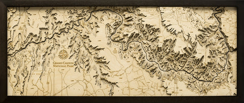
Nantucket Wood Chart Map
A beautiful map of Nantucket. A 3-D nautical wood map featuring Nantucket Island, Massachusetts.
Nantucket is primarily an affluent summer colony. Most of its homes are seasonally occupied, and in the summer months the island's population swells from 10,000 to over 50,000. It's accessible only by boat or by air. The wharves and cobblestoned streets of the Town of Nantucket are lined with restaurants, high-end boutiques and steepled churches. The town’s Whaling Museum recounts the island’s role as a 19th-century whaling hub.
Points of Interest Include:
Brant Point Light, Coskata-Coatue Wildlife Refuge, Great Point Light, Muskeget Island, Nantucket State Forest, Sankaty Head, and Tuckernuck Island.
Wood charts are made from Baltic birch, have a solid wood frame available in two color choices and come ready to hang. Measures 16" x 20". This chart comes in two colors, grey (photos 4-6) and dark brown (photos 1-3). Please note the blue coloring varies based on the frame selected.
Please note these may ship directly from the manufacturer and will have Wood Chart visible on the outside of the box.