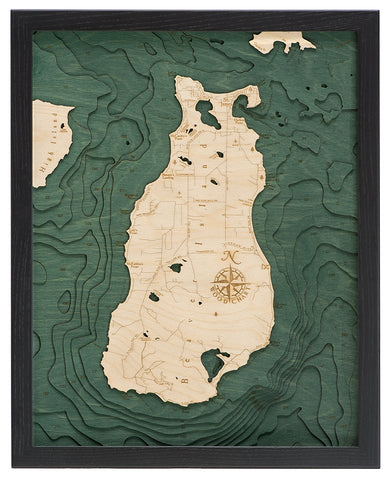
Straits of Mackinac, Michigan Wood Map Art
This map has been discontinued by the manufacturer. Please shop our other wood charts.
A 3-D nautical wood map featuring Michigan's Straits of Mackinac.
Long ago, before rail lines had made it out to Chicago, most immigrants reached the midwest and Great Plains by boat through this strait. It's narrow enough to freeze over in the winter so, unfortunately, this convenient mode of transportation wasn't a year-round affair for our ancestors. Today we're fortunate to have powerful icebreakers to clear our way and the beautiful Mackinac Bridge to connect Michigan's upper and lower peninsulas.
Points of Interest:
Mackinaw City, Mackinac Bridge, Bridge Walk, St. Ignace, Lake Michigan, Lake Huron, Mackinac Island, Blois Blanc Island, Round Island, Cheboygan, and Old Mill State Park.
Measures 24.5" x 31". Wood charts are made from Baltic birch and have a solid wood frame. They come ready to hang.